


The Waikato Integrated Scenario Explorer (WISE) is a dynamic, spatially-explicit computer simulation model that assesses the effects and trade-offs of alternative future development scenarios or the consequences of policy options.
It spatially integrates economic, demographic, environmental (climate, hydrology, water quality, biodiversity) and land use (suitability, accessibility, local influence, zoning) information to undertake these asessments. For a quick overview of the spatial planning tool WISE watch this short video - Click here to view...
The Waikato Regional Council is now advancing the practical application and further enhancement of WISE to support regional and local government planning and decision-making processes.
For the Waikato Region future projections of land use, population, households, workforce, employment, value added for 2018-2068 have been developed, based on WISE model outputs, to inform regional and district planning.
Current projections are based on WISE V1.6 and 2018 census data and are available here to view and download.
Note: The updated Waikato Projections 2023-2073 based on the 2023 census will be released end of 2025.
In addtion to being a key modelling component for the Waikato Projections, WISE has also been used for several other projects. These are presented as case studies. They have included included understanding the pressure and risks to soils resources, exploring the potential consequences of desired economic development, and understadning possible land use consequences of coastal inundation.
For more on the potential uses for WISE - Click here..
The Waikato Reference Scenario is the 'starting setup' for the WISE model. The Reference Scenario provides a plausible future projection based on current policies, plans and associated zoning, current and planned infrastructure, current projections of population and economic growth, and geophysical suitability of the landscape.
The Reference Scenario provides a starting point onwhich to built alternate future scenarios and a 'baseline' set of indicator outputs for comparision with any alternate scenarios. To find out more about the Waikato Reference Scenario and its projection into the future - Click here...
|
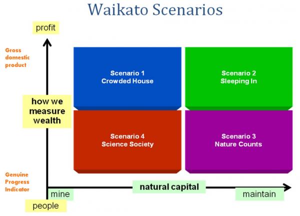
Understanding possible future scenarios can assist in developing more enduring and supported policies for achieving our community outcomes. The Waikato scenarios explore some of the deepest dilemmas of our times: profit versus people; growth versus the environment; global versus local; and rich versus poor. |
|
|
How these dilemmas are resolved might affect our ability to improve economic, social, cultural and environmental well-being and to achieve our Community Outcomes. The scenarios will also help us better recognise and begin to grapple with change and think about how we might respond to it. |
 |
The Waikato Projections (2018-2068) have been completed. The updated Waikato Projections 2023-2073 based on the 2023 census will be released by end of 2025. These projections provide modeled future projections for social (population, households, labour force) and economic (value add, employment by sector) indicators based on most up to date social, economic and land use data... >>
An upgrade of the WISE model has recently been undertaken. Following on from improvements in V1.5 the new version (V1.6) features a number of other improvements. These include: New modelling start date of 2018 and includes an updates starting land use map for 2018 Up-to-date zoning and growth strategy information for the regional territorial authorities A... >>